!["Teton Reflections" [Teton Range from Schwabacher Landing in Grand Teton National Park, Wyoming]](https://www.dvtwist.com/wp-content/uploads/20190907120227-D7200A_14199_DxO_1-cropped-blog.jpg)

Making Plans
From August 31st to September 9th my companion and I took a trip to Craters of the Moon National Monument, Yellowstone National Park, Grand Teton National Park, and the points connecting the three.
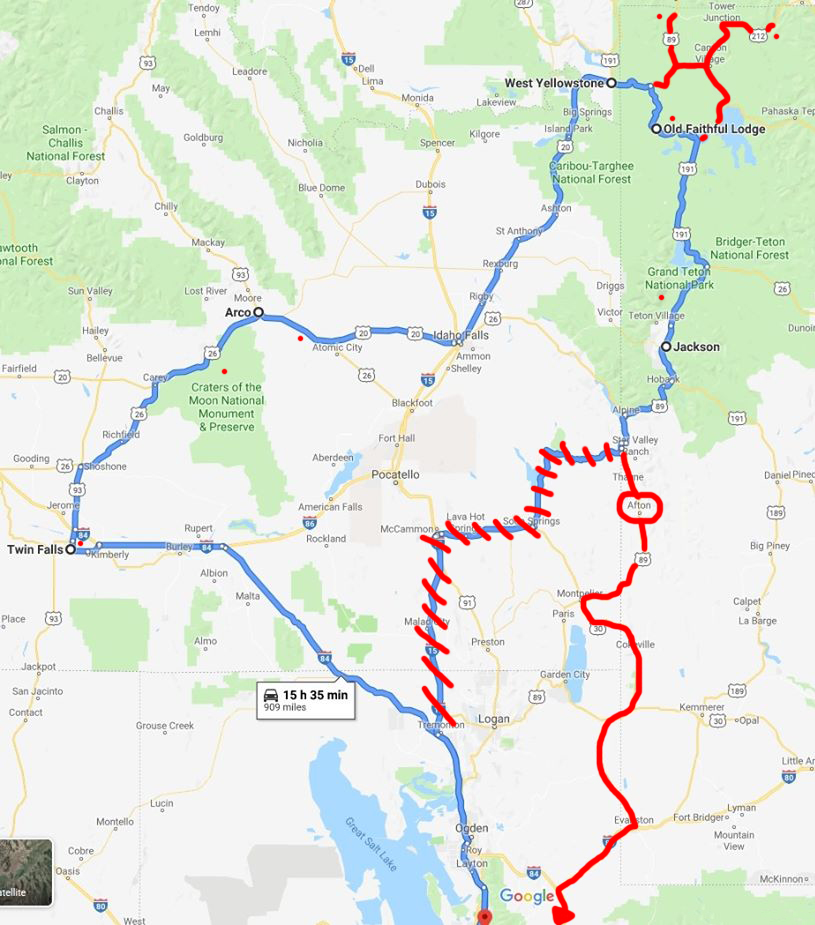
We had purchased our reservations in January, and even then lodging in Yellowstone was almost booked up. We decided that we’d take an afternoon flight on Saturday, August 31st, from San Jose, California, to Salt Lake City, Utah. We’d pick up our rental car then drive that night to Twin Falls, Idaho, after making a stop at a Trader Joe’s for supplies. On Sunday we would stop at Twin Falls’ great attraction, Shoshone Falls, then continue on to Craters of the Moon National Monument. We’d spend our second night in Arco, Idaho, and on Labor Day we would drive from Arco to West Yellowstone, Montana, with stops at the EBR-1 National Historic Landmark and possibly Idaho Falls. On Tuesday the 3rd we would get an early start and head into Yellowstone National Park – hopefully before the crowds. Our cabin for the next four nights wouldn’t be ready until 4pm, so we would spend most of Tuesday driving through the park. Wednesday, Thursday, and Friday would be spent exploring Yellowstone. All we knew was that we wanted to visit Mammoth Hot Springs, Lamar Valley with its legendary wildlife viewing opportunities, and that our cabin would be about a quarter mile from Old Faithful. Any other plans would be made once we got to the park. On Saturday we would leave Yellowstone and stay in Jackson, Wyoming, for two nights to visit Grand Teton National Park. Then on Monday we’d drive back to Salt Lake City to catch our evening flight back to California.
I had originally planned on staying two nights in Jackson to explore Grand Teton National Park and driving all the way to the airport on Monday September 9th, but a smarter head prevailed and suggested we get a motel closer to Salt Lake City. While searching the area with Google Maps highlighting all the motels in the area, I noticed a small blue dot way up a canyon just outside of a small town. I zoomed in and saw The Old Mill Cabins. It looked perfect. Three cabins on a piece of property about a mile from the main highway. So we decided to cancel one night in Jackson and spend our last night in Afton, Wyoming – about an hour and a half closer to Salt Lake City.
I decided to purchase a guide from dirtinmyshoes.com, a website run by a former park ranger. It was a full four day itinerary laid out to maximize our efficiency in the park and to hit all the attractions. It was a very good guide, but after reviewing it decided that it wouldn’t work well for us as photographers who wanted a bit more flexibility to chase the light and look for wildlife. I requested and got a refund, but the guide was good enough that I wanted to mention and recommend it here for someone who wants a good schedule to make sure they see everything important.
Plans were made, now all we had to do was wait eight months for our plane.
Food for the trip would have to be carefully planned. Four days in a cabin in Yellowstone National Park would essentially be camping. There was no cooking allowed in the cabin, nor was there a refrigerator for storing food. So before we left we prepared two pounds of jerky along with various other dry foods to last us though to Jackson.
Salt Lake City and the Drive to Twin Falls
Our trip started off with an afternoon plane ride from San Jose, California, to Salt Lake City, Utah, where we picked up our rental car for the road trip ahead. Being somewhat thrifty we had reserved the cheapest car on the list, but when we went to the counter to pick it up we were informed that there had been a computer glitch and they were woefully overbooked. This is definitely NOT what you want to hear when you just stepped off an airplane with nine days of plans ahead. The kind lady at the Dollar Car Rental counter assured us that, since we got there at about the time that many rental cars were being returned, she would have a car for us in about half an hour. When she called our name in only fifteen minutes, she told us that we would be getting a 2019 Toyota Camry instead of the econobox on our reservation. This could be a mixed blessing. Sure, the car would be nicer, but we would also have a bigger car with lower gas mileage for the 1,000 mile trip ahead of us. So we headed into the garage, loaded up the car, attached my dashcam to the windshield, and went on our way.
Since we had taken a later flight from San Jose, most of the drive to Twin Falls was in the dark. The fancy Toyota was a dream to drive. It sipped gas, averaging about 40 miles per gallon on our trip, and the adaptive cruise control was great. Set the cruise for 70, and if the car ahead slowed down the cruise control would compensate – even braking on its own if necessary. They got out of the way and the car would go back up to 70. Lane guidance, or whatever it’s called, would beep if I changed lanes without my signal and it earned me a “use your turn signal!” from my co-pilot each time it happened.
Our first stop was at a Holiday Inn in Twin Falls, Idaho. We wanted to be sure of a decent room that first night since we couldn’t be sure of what the little motels in Arco and West Yellowstone would be like. Upon check in we were informed that the elevator wasn’t working and they couldn’t get a repair person out for the weekend. And we were on the third floor. Out of rental cars, broken elevator. I hoped this wouldn’t be how the rest our trip would go. We decided on what had to up upstairs and what could be left in the car, and then retired for the evening.
Shoshone Falls
The night went well, and after schlepping our suitcases and cameras downstairs we headed off for the official First Day of our trip. I had discovered the previous day that out of habit I had put on my work slip-on loafers instead of my hiking shoes when we left home, so our first stop would be at Walmart for a cheap pair of shoes and a roll of tape to hold down the power cable of my portable GPS logger.
We had seen photographs of Shoshone Falls online and since we would be in the neighborhood, decided to make it our first sightseeing stop on the trip. There is a nice park at the falls, complete with a hut where you can buy all sorts of Idaho and Shoshone Falls memorabilia. Shoshone Falls has been called “The Niagara of the West.” It is 900 feet wide and over 200 feet tall, making it one of the largest waterfalls in the United States. Its flow can vary wildly, from the spring melt, when the Snake River is flowing at its maximum and over 1,300 gallons per second fall over the rocks, to the summer when the the flow is diverted to farmland and the Department of Reclamation recharges the reservoirs upstream and the falls go nearly dry. When we went the flow wasn’t nearly at its peak, but there was still plenty of water and the lower flow made the spectacular rock riverbed more visible. Shoshone Falls is just a couple of miles upstream from where Evel Knivel made his failed attempt to jump over the Snake River Canyon in 1974. We very briefly discussed making a short detour, but taking an hour or more to see a granite slab didn’t make a whole lot of sense.
On the Surface of the Moon
!["Moonwalk" [Hikers on Inferno Cone in Craters of the Moon National Monument, Idaho]](https://www.dvtwist.com/wp-content/uploads/20190901132324-D7200A_13073_DxO-blog.jpg)
After the falls we headed to our second destination: Craters of the Moon National Monument. As we drove up Highway 26 past Carey, Idaho, the landscape started to change. Farmland gave way to hills, and the farther north we went the more black lava rock covered the landscape until we were completely surrounded by the ancient lava flow by the time we turned onto the park road.
This land of caves and black lava truly was otherworldly. Volcanic rock ranged from immense masses of hardened lava flows to crunchy chunks of cinder that were blown out of the ground as liquid and cooled as the molten rock rained over the landscape. We arrived under a mid-day sun on a ninety-degree afternoon and went to the visitor’s center to be screened for fungus.
Pseudogymnoascus destructans was discovered in New York in 2006, and causes a disease in bats called white-nose syndrome. It’s not known exactly how or when the fungus came to the Americas, but since it was discovered the disease has spread into 33 states. Bats in North America don’t have the immunity to the disease that those from Europe and Asia do, and it is estimated that white-nose syndrome has killed over 6-million bats since it was introduced to the New World. Because the fungus’ spores can survive on clothing and equipment, no clothing, cameras or anything else that has ever been in any cave is allowed inside the lava tubes at Craters of the Moon.
Declared fungus-free, we got our cave permit and headed into the 90-degree day. As we hiked out to the caves we realized that there was one very important thing that we forgot to pick up at Walmart: water. The air was dry and hot, and being surrounded by black lava didn’t make it feel any cooler. We ended up deciding that one cave was enough for us that day, and we moved on to Arco just after 5pm – but not before stopping at the campground to fill our water bottles.
Arco, Idaho, and the Nuclear Age
We left Craters of the Moon with enough time to get to Arco, Idaho, before dark. We checked in to the Arco Inn (with its flies and broken ice machine) and unloaded the car. When we unpacked I discovered that one of the two rubber bands holding my dashcam to its mount had broken. My dashcam installation was a bit unorthodox. Because the camera is very compact, designed to be attached to motorcycle helmets actually, it could not rest on top of the mounting bracket. Instead, the mounting “platform” had to be stuck to the window upside down, and the camera rubber-banded below. I didn’t trust that the single rubber band of questionable age would survive the entire trip, so after we got settled in I went to see if I could get one from the innkeeper. She made a valiant effort, but aside from some hair scrunchies and tiny rubber bands from her daughter’s braces, there were no rubber bands to be found. And so the next morning on the way out of town we stopped at the local dollar store for a bag of rubber bands (and a couple of gallon bottles of water.)
!["Number of the Beast" [Submarine Sail at Idaho Science Center, Arco, Idaho]](https://www.dvtwist.com/wp-content/uploads/20190902072938-D7200A_13115_DxO-cropped-blog.jpg)
Before we left Arco we had to make a stop at the “Devil Boat.” I found out about this attraction on RoadSideAmerica.com, a website that anyone embarking on a road trip should visit before heading out. The “boat” is the sail of the nuclear fast attack submarine USS Hawkbill, hull number 666, and it is “surfacing” at the Idaho Science Center. The Biblical line from Revelations, “And I stood upon the sand of the sea, and saw a beast rise up out of the sea….” seems appropriate for a nuclear attack submarine, but now instead of rising up out of the sea the boat has taken on another name: “The Submarine in the Desert.” Arco is near the Idaho National Laboratory, one of the primary nuclear research facilities in the United States, which has been developing nuclear reactor technology since the 1950’s, including reactors for submarines. Because of Arco’s location near the facility and its ties to the United States Navy, the sail was donated to the town when the Hawkbill was decommissioned in 2001.
The submarine sail is the centerpiece of the Idaho Science Center, a somewhat grandiose name for what is essentially the sail, a torpedo, a gazebo, and a metal shed that houses a collection of photos and memorabilia depicting the history of nuclear power. When we were there, the shed was manned by a volunteer who used to serve on board nuclear submarines and he spent half an hour sharing stories from his days in the Navy.
About twenty miles east of Arco is EBR-1, the world’s first nuclear power plant. We were there on Labor Day, which turned out to be lucky for us since the plant is only open for tours from Memorial Day weekend through Labor Day. We had the option to take a tour with a guide or explore on our own, so we ended up starting with the guide then breaking off from the tour to take photos. We walked though the control room and on top of the nuclear reactor. From there we continued downstairs past the electric generator and down past the heat exchangers and to see where the nuclear fuel was stored both before and after use. There were rooms where 39 inch thick windows separated workers using mechanical arms from the radioactive material inside, and rooms where bricks of nuclear fuel created by the plant were handled. After taking the tour I returned to make a video walking through the entire plant.
!["The Atomic Age" [EBR-1 Nuclear Reactor Control Panel in Arco, Idaho]](https://www.dvtwist.com/wp-content/uploads/20190902091739-D7200A_13162_DxO-blog.jpg)
The plant’s primary purpose was not to generate electricity, but to test the theory that a nuclear breeder reactor could generate more fuel than it used. In 1953 the hypothesis was confirmed when scientists detected that the reactor was converting non-fissionable uranium-238 to fissionable plutonium-239, and in higher quantities than it consumed. The plant continued to operate as an experimental reactor until decommissioned in 1964. It was declared a National Historic Landmark the following year.
!["This Idea Will Never Fly" [Nuclear Jet Engines at Idaho National Laboratory, Arco, Idaho]](https://www.dvtwist.com/wp-content/uploads/20190902100850-D7200A_13181_DxO-cropped-blog.jpg)
Outside of the power plant is an interesting display of two large pieces of equipment. In the late 1940s nuclear power was the wondrous new tech of the age, and in 1947 the idea of powering long range bombers with nuclear jet engines was born. The idea was that a nuclear reactor would be mounted in an airplane, and the engines would draw in air to be heated by the nuclear core instead of traditional jet fuel before being expelled through the exhaust. In the early to mid 1950s two test engines were created to test the idea. Rumor had it that the Russians had developed such an airplane, and so it was full speed ahead for the United States to develop its own. After spending about $1 billion on the project, the discovery that the Russians didn’t have a nuclear airplane after all, and with development of intercontinental ballistic missiles rendering the idea of a bomber with unlimited range moot, the project was canceled by President Kennedy in 1961.
Idaho Falls
!["Order and Chaos" [Diversion Dam Waterfall in Idaho Falls, Idaho]](https://www.dvtwist.com/wp-content/uploads/20190902115933-D7200A_13199_DxO-cropped-blog.jpg)
After EBR-1 we continued to Idaho Falls to fill up our tank because we didn’t want to have to buy any more gas in Yellowstone than we had to. We continued into town as Highway 20 turned into West Broadway Street and stopped in a small parking lot just after crossing the Snake River.
The river bisects Idaho Falls, where the town was built near the site of a set of rocky rapids. In the early 1900s a diversion dam was built in the river to channel water to a hydroelectric power plant, and the water flowing over the dam onto the rocks that made up the rapids created the “Falls” that are seen today. We crossed a footbridge to a small island where we spent a few minutes exploring a Japanese garden. From there we crossed another bridge to the other side of the river.
!["Straight and Narrow" [Mormon Temple in Idaho Falls, Idaho]](https://www.dvtwist.com/wp-content/uploads/20190902114905-D7200A_13198_DxO-blog.jpg)
There is an eleven mile greenbelt along the banks of the Snake River, about five miles up and down each side. We only walked a short distance, just enough to get a good view of the falls and surrounding city. Although Utah is known for its Mormon population, Idaho comes in second with over 25% of the state’s population belonging to the Church of Jesus Christ of Latter-day Saints. I really like the architectural style of the LDS temples, with their straight lines and boxy shapes. Surprisingly, even though we flew in and out of Salt Lake City, the one in Idaho Falls is the only one I photographed.
We wanted to get to our next motel early so we only spent about an hour in Idaho Falls before getting back in the car and on the road. About half hour up the highway we realized that we forgot to get gas, so we had to make one last stop before we got to West Yellowstone.
Yellowstone National Park
West Yellowstone, Montana, is at the very border of Yellowstone National Park. We decided to stay here because we wanted to get into the park before the lines of cars formed at the entrance gate. Our room was at the One Horse Motel, a small motel across the street from a town park and just off the main road. There was no elevator to break, and as far as we knew the ice machine worked fine. We were even gifted a small stuffed bear when we checked in. It would be four days before we would have access to hot food again, so we took a walk to a local grocery store and picked up something we could cook in a microwave oven.
!["The Start of Something Big" [Lower Yellowstone Falls in Yellowstone National Park, Wyoming]](https://www.dvtwist.com/wp-content/uploads/20190903061611-D7200A_13210_DxO-blog.jpg)
We awoke early on Tuesday, September 3rd, and headed into Yellowstone. We weren’t expecting long lines at the entrance, but that there was only had a single car in front of us did surprise us. We breezed right through the entrance gate and were on our way. The park road cut through the forest and we saw our first wildlife in the park, a male elk that was far off in the woods and a female with two calves closer to the road. Our cabin would not be ready until 4pm, so we continued east across Norris Canyon Road until we reached Canyon Village, where we cleaned the Utah and Idaho bugs off the windshield. We then turned south and made our first real stop, at Artist Point. This is one of the most photographed spots in the park, and I wasn’t going to be left out. From the viewing area we could look up at the start of the Grand Canyon of the Yellowstone, where the Yellowstone River had flowed from the harder rock to the softer rock, eroding it away to form the canyon while creating Lower Yellowstone Falls.
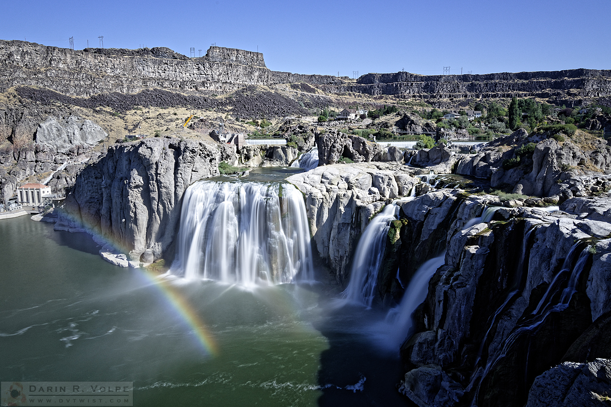
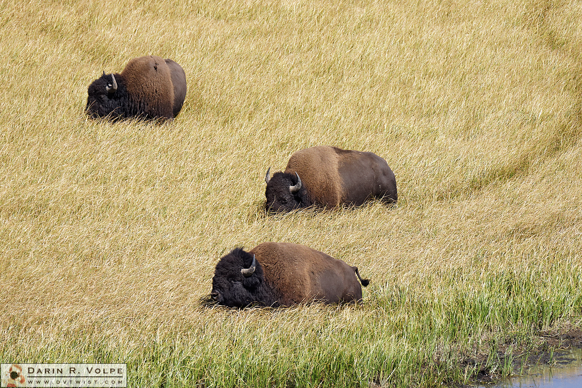
From Artist Point we traveled south down Grand Loop Road and into Hayden Valley. Before long we saw a herd of bison at the edge of the Yellowstone River. We pulled off the side of the road and watched, but they were too far away for photographs so I shot a short video of the valley instead. Seeing the bison was exciting, but I hoped that we’d see some closer-up. Perhaps we’d have another chance in the coming days. After watching them for a while we got back into the car and continued on our way.
!["I'm Actually Canis Latrans" [Coyote in Yellowstone National Park, Wyoming]](https://www.dvtwist.com/wp-content/uploads/20190903065433-D7200B_01992_DxO-cropped-blog.jpg)
Parked cars are always a good sign that there is something to see, so when we saw a row parked on the side of the road we pulled over to see what the attraction was. In the grasses was a coyote! I had never seen one in the wild before and this one put on quite the show, running and jumping through the grass in search of critters for breakfast. We watched until it got out of camera range and got back into the car, only to see another coyote a little way down the road hunting along a small river. We watched that one hunt and splash though the river until it ran out of view.
!["Rolling on the River" [American Bison Wallowing in Yellowstone National Park, Wyoming]](https://www.dvtwist.com/wp-content/uploads/20190903090541-D7200B_02044_DxO-cropped-blog.jpg)
A bit further down the road we spotted a couple of bison in the distance, so we turned around and found a spot to park. We hiked down to the river where we watched one cross to the other side and take a roll in the mud. This one was definitely close enough for a photo or two – it seemed that we’d get some bison photos on this trip after all.
!["Ahhhh, West and Weewaxation at Wast!" [Fisherman in Yellowstone National Park, Wyoming]](https://www.dvtwist.com/wp-content/uploads/20190903092959-D7200A_13245_DxO-blog.jpg)
A fisherman was standing in the river fly fishing nearby. I thought it was odd to allow fishing in a place where all other wildlife is federally protected. You’re not even supposed to get close enough to a robin so that it changes its natural behavior, so what is it that makes fish an exception to the rules? Fishing has been a tradition in Yellowstone since it was first discovered, and in 1899 the government began stocking the rivers with both native and non-native species. This continued until 1955 when all stocking programs were discontinued. Today’s anglers are helping to conserve native species by catching the non-native fish. In most areas of the park it is illegal to release any non-native fish caught, and barbless hooks are required so any native fish caught can (and must) be returned to the water unharmed – well, as unharmed as they can be after getting pulled out of the water in the first place.
With so much extra time before we could check in to our cabin, we turned around at the south end of the valley then drove back to Artist Point. We wanted to see if the light would be better once the sun rose high enough so the falls weren’t in shadow, but I found that I preferred the early morning light. Then we headed south for another trip through Hayden Valley. The bison herd we first saw had moved closer to the road by now, so we stopped again to watch them. The wind had started blowing hard, and as they pushed their way through the tall waving grasses they left trails behind them. Eventually the herd crossed the river.
!["Like a Duck to Water" [American Bison in Yellowstone National Park, Wyoming]](https://www.dvtwist.com/wp-content/uploads/20190903121120-D7200B_02130_DxO-blog.jpg)
!["Not So Black" [Black Pool in West Thumb Geyser Basin in Yellowstone National Park, Wyoming]](https://www.dvtwist.com/wp-content/uploads/20190903135610-D7200A_13283_DxO-cropped-blog.jpg)
We left the bison and drove on to the West Thumb Geyser Basin on the western edge of Lake Yellowstone. This was where we got our first sight of Yellowstone’s famous hot springs including the 53-foot deep Abyss Pool and the incredible clear turquoise water of “Black Pool,” which hasn’t been anywhere close to black since the water heated up and killed the cyanobacteria in 1991. We walked all around the boardwalks of West Thumb until it was late enough to check in to our cabin at the Old Faithful Lodge and Cabins.
We got back on the road and headed north until we saw the signs for Old Faithful. We followed the signs to the Old Faithful Inn where, after waiting in line at the lobby, were told we were at the Inn and not the Lodge. So back into the car we went and continued down the road to the Old Faithful Lodge. Now, this is where I must say that our check-in experience was less than stellar. The person checking us in asked if we would like to opt out of housekeeping service and help save the world (and $5 per night.) We generally prefer to not have people coming into our room but this would be a four-night stay. While we were still discussing it, and before we decided, she plugged “yes” into the computer and generated our invoice. No housekeeping turned out to work much better in a hotel than the cabin for reasons that I’ll get into later. She rushed us through the whole process and didn’t give very good directions to the cabin. We got back into the car, but between the desk clerk’s directions and the really bad signage on the roads around the cabin, we ended up taking the scenic route all the way back out to the main road and looping back into the cabin area again. I decided to just turn into a side road next to the lodge and lucky us, it happened to take us straight to the cabin.
Each cabin was a duplex, a rectangular building with a door on each end and a divider wall in the middle. You could hear the neighbor, but we were lucky enough that the guest on the other side of the wall was a quiet single woman for most of the time we were there. The cabin couldn’t have been in a better spot. It was on the perimeter road with it’s back to the Firehole River, there was a geothermal steam vent visible in the distance, and it was only a five-minute walk to Old Faithful and the Upper Geyser Basin. The restroom/shower room was only a short walk away, but not so short that there would be restroom/shower-seeking foot traffic next to our room. Were also far enough away from the lodge that we couldn’t hear the rumbling of the fans.
We were beat and turned in early to plan our next few days. We were expecting the warm weather to turn rainy in a couple of days, so we decided that our best bet would be to go to Mammoth Hot Springs the next day, Lamar Valley to look for wildlife the day after that, and then spend the next couple of days exploring the thermal areas near the cabin.
!["Liquid Stairway" [Main Terrace at Mammoth Hot Springs in Yellowstone National Park, Wyoming]](https://www.dvtwist.com/wp-content/uploads/20190904105452-D7200A_13451_DxO-cropped-blog.jpg)
!["Sleeping Giant" [Tourists at Excelsior Geyser Crater in Yellowstone National Park, Wyoming]](https://www.dvtwist.com/wp-content/uploads/20190904071013-D7200A_13331_DxO_2-blog.jpg)
We were up at the crack of dawn again on Wednesday for our drive up to Mammoth Hot Springs. On the way we stopped off at Midway Geyser Basin to see Grand Prismatic Spring and took a side trip on Firehole Lake Drive. Mammoth Hot Springs is on the very northern edge of the park and is made up of three sections: The upper terraces viewable from the loop road, Main terrace where Canary Springs is perched high above the valley below, and the lower terraces that fall like a staircase down the mountain. It is a land of steaming water falling down colorful limestone terraces, and of white remnants of dried up springs. It is constantly changing. For example, Minerva Terrace can flow so much that it has covered the boardwalks in limestone, and a search on the Internet shows water flowing over a multitude of colored limestone terraces, but when we were there it was completely dry. People who visit the park will return years later to see their favorite features dry and assume that the springs are drying up. In reality the same amount of water flows, it has just moved to create or revitalize other terraces.
Thursday was our drive to Lamar Valley. Now, if you’re not familiar with the American West you may be surprised at the distances involved. There are 29 countries smaller than Yellowstone National Park, and it is only 250 square kilometers smaller than Cyprus in the Mediterranean Sea. Delaware and Rhode Island would both fit inside the park simultaneously, and it’s only fifty square miles smaller than the island territory of Puerto Rico. The drive from Old Faithful to Lamar Valley is about seventy miles, so to get to there by sunrise, we left the cabin at about 4am.
!["Native American" [Female Pronghorn in Yellowstone National Park, Wyoming]](https://www.dvtwist.com/wp-content/uploads/20190905060152-D7200B_02229_DxO-cropped-blog.jpg)
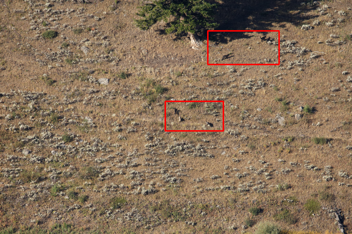
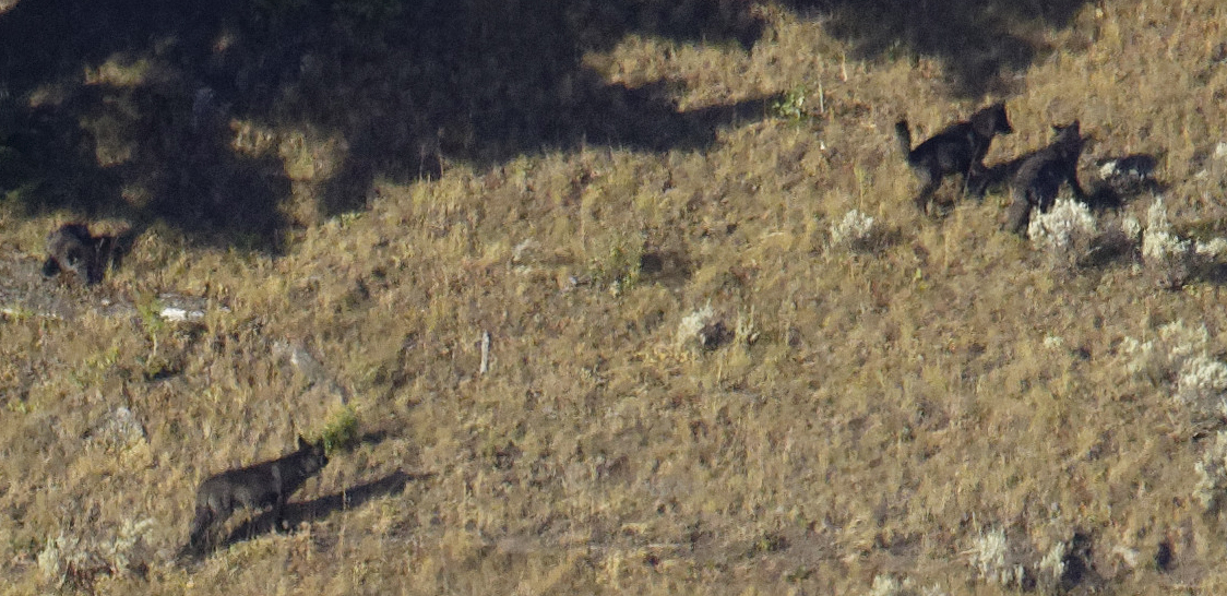
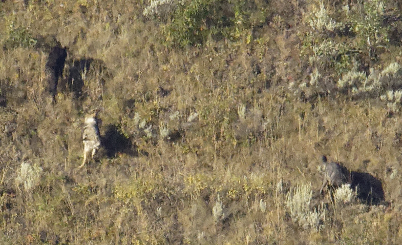
Our first wildlife encounter of the day – unfortunately while still too dark for photos – was a mother black bear and at least one cub in the forest near Mount Washburn. As we entered Lamar Valley at around 6am we began seeing cars lined up on the side of the road. As I mentioned before, one sure way to know there’s something worth seeing is by watching for stopped cars. So we pulled into the first available spot to see what everyone was looking at. We looked all around the landscape but saw nothing, and that’s when we noticed that many people had spotting scopes set up and pointed toward the distant riverbank. I asked one of the people who had a scope what the attraction was. They directed me to some dots moving at the river’s edge that were probably a half mile away. They let me look through their scope and I saw the pack of wolves walking along the riverbank. Even with a 600mm lens, all I was able to get were some tiny dots moving in the landscape. We also saw pronghorn in the valley, a pack of coyotes, and, of course, bison. We continued into the mountains toward the northeast entrance where we saw more white dots high up on the mountainside. Those dots were mountain goats.
We wanted to get back with enough time to hike up to the Grand Prismatic Spring Overlook. It would be a two hour drive, plus time for the hike and to sightsee along the way, so we started back in the late morning. We made a brief stop at an overlook at the Grand Canyon of the Yellowstone and then at Gibbon Falls. The sides of the canyon around the falls are a grayish-red, but the riverbed is very black lava. White water falling over that lava has eroded it away into ribbons that parallel the river. The contrast of the white and black immediately grabbed my attention, and this cascade became my favorite of all the waterfalls we saw.
!["Water Over Rock" [Gibbon Falls in Yellowstone National Park, Wyoming]](https://www.dvtwist.com/wp-content/uploads/20190905115117-D7200A_13599_DxO-blog.jpg)
This was probably the single thing on the trip that I took the most photos of. I knew that I wanted to get it with just the right amount of motion in the water, and yet shooting handheld I wanted to also be sure the rocks stayed sharp. This turned out to be one of my favorite photos of the trip.
After leaving Gibbon Falls we drove non-stop to the Fairy Falls Trail. We were there by noon and on our way to the Grand Prismatic Spring overlook.
!["American Icon" [American Bison in Yellowstone National Park, Wyoming]](https://www.dvtwist.com/wp-content/uploads/20190905130712-D7200B_02329_DxO-cropped-blog.jpg)
There was only one photo that I needed to get on this trip. There were plenty that I wanted and was pretty sure I would get – Old Faithful, the terraces at Mammoth, whatever wildlife I saw – but the iconic Yellowstone photo for me was a bison at a hot spring or geyser. Shortly after starting up the trail to the Grand Prismatic Spring overlook we encountered two bison that were very close. One was laying on the soil, the other walking towards me. In the distance, steam rose from Grand Prismatic Spring. The odds of a bison walking in front of an Old Faithful eruption or across the colorful algae around the spring were pretty low, so I knew this was going to be the scene I was looking for.
!["Eruption!" [Old Faithful Geyser in Yellowstone National Park, Wyoming]](https://www.dvtwist.com/wp-content/uploads/20190905175228-D7200A_13735_DxO_2-blog.jpg)
After spending a couple of hours on the Grand Prismatic Spring overlook and trail, we started our return trip to the cabin. We got there at around 5:30pm and figured that, having been in the park two days already, it was time to go see Old Faithful. The clear blue skies had started turning cloudy by now so I had a nice background for a sunset photo of the famous geyser. It went off right on schedule, and after the sunset we returned to our cabin.
Friday would be our last full day in Yellowstone. We started the day with a walk through Upper Geyser Basin. Its most famous feature is, of course, Old Faithful. It erupts relatively faithfully every 90 minutes, but there is a lot more to see here. This area has the largest concentration of hot springs in the world and is the largest geyser basin in Yellowstone. Over 150 geysers are scattered around the basin and it’s where my favorite spring is located, the diminutive yet fascinating Beach Spring.
!["Terraformers' Descendants" [Cyanobacteria at Doublet Pool in Yellowstone National Park, Wyoming]](https://www.dvtwist.com/wp-content/uploads/20190906174920-D7200A_13985_DxO-blog.jpg)
The rain we were expecting started coming down hard about halfway through our walk through Upper Geyser Basin. We bundled up our gear and enjoyed watching the raindrops falling onto the various pools as we returned to our cabin. Once the rain died down we took a short drive out to Biscuit and Black Sand Basins where it rained on us again, then returned to a beautiful double rainbow by the cabin and another walk through Upper Geyser Basin for the sunset.
Remember when I said that foregoing housekeeping and saving the Earth wasn’t such a great idea? By Friday the floor of the cabin was covered in dirt and debris that we had tracked in over the past three days. We had to rummage for and temporarily hijack a broom from a closet in the shower room to sweep the cabin out.
!["Doubly Beautiful" [Doublet Pool in Yellowstone National Park, Wyoming]](https://www.dvtwist.com/wp-content/uploads/20190907060027-D7200A_14026_DxO-cropped-blog.jpg)
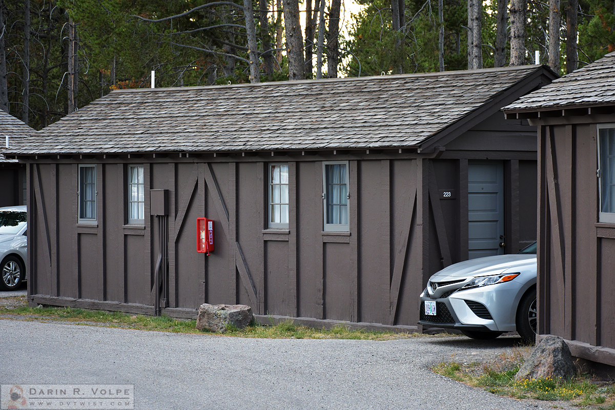
I was out of the cabin at 5:30am on the morning of Saturday, September 7th to catch the morning light at Doublet Pool and Geyser Hill. I got to see Old Faithful go off one more time from the hill, then after a few more photos on Upper Geyser Basin it was time to head out of Yellowstone. I would definitely recommend staying at the Old Faithful Cabins when visiting Yellowstone National Park. I would especially recommend cabin 223 or one of the adjacent cabins if you can, although I’m not sure if you can reserve a specific cabin when making reservations online.
Jackson Hole and Grand Teton National Park
The weather stayed dry as we drove down Highway 89 into Grand Teton National Park. When we reached the fork at the Park Road and the main highway, we decided to continue on US 89 along the Snake River. This would be a faster route through the park, then we could check in at the motel early and return to the park again in the late afternoon.
!["Golden One" [Horse Grazing in Mountain Landscape in Grand Teton National Park, Wyoming]](https://www.dvtwist.com/wp-content/uploads/20190907104912-D7200A_14140_DxO-blog.jpg)
Because the highway runs down the middle of the valley at quite a distance from the mountains, it really showed off how the Teton Range thrust out of the earth at the edge of the flatlands. From the valley floor, the Tetons rise for an elevation gain of up to 6,987 feet in only about 2-1/2 miles. I’ve ever seen mountains as jagged as these anywhere else. Along the way we stopped at the Elk Flats Ranch turnout. This area was once a cattle ranch, but today it is known as an excellent place to see bison and other wildlife from the roadside. When we went it was being used as grazing land for horses from a local ranch.
We continued onward and stopped at Schwabacher Landing towards the south end of the park. The view of the mountains from the riverbank there is probably the most photographed view in the park, so much that I joked that there should be a concrete pad with three markers stating “Place tripod legs here.” But there’s a reason why this place is so photographed – it’s hard to find a more impressive landscape than the Tetons reflecting on the Snake River.
After we left Schwabacher Landing we continued south to the town of Jackson, Wyoming (“Jackson Hole” refers to the entire valley) to check in to our motel. After four days of eating nuts and berries like Boo-Boo Bear in Jellystone Park, it was time to feast like Yogi. We had planned on this, so when we reserved our room in Jackson we made sure it had a kitchen. After a trip to the supermarket for shrimp and New York steak we returned to the room. When we left for the market the neighboring room had the bathroom fan on, and it was still running the whole time we were out. It was quite loud, and it would not be good if our neighbors were going to be the kind of people who never turned it off. We asked at the front desk if we could change to an end room, but although we were the only car in the parking lot we were informed that the other rooms were all taken. In the end we decided to slip a note under the neighbor’s door that said, roughly, “please refrain from leaving the bathroom fan on while you’re not using it because it can be heard clearly in the neighboring rooms.” I was sure to write it in a way that it could be easily be mistaken as a note from the management. We left the motel and returned to the park, but the weather was already turning rainy again so we didn’t stay long. We came back to a full parking lot – and no sound coming from the neighbor’s fan.
!["Jackson Lake" [Grand Teton National Park, Wyoming]](https://www.dvtwist.com/wp-content/uploads/20190908070838-D7200A_14232_DxO-cropped-blog.jpg)
Our plan for Sunday was to drive back into Grand Teton National Park and take the Park Road north looking for wildlife. We left at dawn and went as far north as Jenny Lake, but the weather didn’t cooperate and the rain was soon coming down hard. But when you go all the way to Wyoming you take what you get, and we stopped at a couple of turnouts to try to get some interesting photos in the rain.
!["Teton Tips" [Mountain Range in a Storm - Grand Teton National Park, Wyoming]](https://www.dvtwist.com/wp-content/uploads/20190908072559-D7200A_14236_DxO-blog.jpg)
We went back to the motel in Jackson for breakfast, then checked out and returned to the park. The rain had died down a bit, so we decided to make a stop at the Lawrence S. Rockefeller preserve. The preserve was donated by the grandson of J.D. Rockefeller of Standard Oil fame as part of the family’s long history of land donations to the National Park system. I came in as a car was getting ready to pull out of a space and was told by a volunteer to loop through the parking lot, come back around, and I’d get the next available spot. So I did, passed by the volunteer, and took the first available spot. Now, this spot was the first place you could fit a car as you pull in and the volunteer was maybe 25 feet behind us. We loaded up our camera gear, which includes us both getting our waist packs out of the trunk and putting them on, me putting on my jacket, then getting my second camera and 600mm lens and hanging that over my shoulder, pulling the monopod out of the trunk and attaching that to me…anyway, this is not a quick process so we must have been unloading the car for about five minutes. Then, before we went on the trail I wanted to get more information on the preserve so I stood outside the car in the middle of the road waiting for the volunteer to finish up with the people she was talking to. After a couple of minutes I decided I didn’t want to wait anymore and we headed off on the trail. After a brief stop at the visitor’s center we continued on our walk. Lucky for us it started raining and we decided to turn back. Another hiker coming up the trail informed us that our car was being towed. I didn’t take her seriously – I mean, who would call a tow truck all the way out to the middle of nowhere and strand two tourists without a vehicle in a place where sections of the trail were closed due to a bear living there? But when we got back to the parking lot we were approached by another volunteer who immediately scolded me for parking without being directed by the first volunteer, our car had orange cones around it, and we were told that they were just about to call law enforcement to get the car moved. I was not happy and let him know that the first volunteer didn’t indicate that there were limited spaces, that I have never in all of my travels been to a National Park where you couldn’t park in an available space, and that I had parked directly in front of the volunteer, spent several minutes unloading the car, and stood essentially in front of her for another couple of minutes before starting on the hike. The volunteer admitted that maybe they were not doing a great job of informing people since at the same time there was one other car surrounded by the orange cones of shame. Once the situation deescalated the volunteer explained that one provision of the Rockefeller donation was that there would be limited parking spaces at the site and that’s why they had a volunteer directing cars to parking spaces. I suggested that they should have, I don’t know, perhaps some signs stating that parking is limited and not to park unless directed. The answer was that the stipulation of Rockefeller’s donation also limited signage. With the parking situation behind us, we loaded up the car and decided to continue up the road to see where it would go. The road eventually made its way out of the park and connected with a highway returning to Jackson from the west.
A Rainy Night in Afton
We continued on US 89 along the Wyoming/Idaho border to our next stop in Afton, Wyoming. We turned onto the road heading into the hills until we found the Old Mill Cabins, hidden away just far enough up the canyon that we thought we missed it. Our cabin was one of three log cabins on the property. They were all surrounded by a lawn with just enough distance separating them. Being from dry California where drought is always an issue, we were surprised to see a lawn sprinkler running on the freshly rained-on grass. A sprinkler that ran the entire time we were there, even during the rainstorm that came later that evening. Another thing that was on the grass – in a lot of places – was bear scat. We hoped that this was a sign that we’d get to photograph a bear on the trip, but it was not to be. Tonight would be our last before returning home, and we enjoyed our last evening sitting on the porch watching and listening to the thunder and lightning. It was the perfect place to spend the last night of our trip.
The End of the Road
Monday came, and it was time to return to Salt Lake City to fly home. We continued down Highway 89 as it zigzagged along the Wyoming border, crossing into Idaho then back to Wyoming a short time later, then in and out of Utah once before connecting with I-80 and going into Utah yet again on our way to Salt Lake City.
!["Dinosaur Under the Stars" [Natural History Museum of Utah]](https://www.dvtwist.com/wp-content/uploads/20190909131857-D7200A_14266_DxO-reduced-blog.jpg)
We weren’t flying out until 7pm so there was time to stop at the Natural History Museum of Utah. The museum is located at the University of Utah in the hills overlooking Salt Lake City. Exhibits ranged from dinosaurs to geology to Native American art, and much more. Most exhibits were focused on the natural history of Utah. The impressive modern building was opened in 2011, and we began our visit on the fifth floor where a viewing deck would have had a a great view of the the city and lake if it weren’t for the smog. On the rest of the fifth floor were the climate, astronomy, and Native American exhibits, then the path descended past geology exhibits and prehistoric people’s exhibit on the floor below. There were two temporary exhibits, the gem and mineral gallery and, ironically for us, a Yellowstone exhibit. Turns out we didn’t even have to leave Salt Lake City on this trip at all! From there we passed an exhibit on the Great Salt Lake before following the snaking path though the dinosaurs. There is a paleontology lab on site with huge windows where we saw the scientists sawing a plaster casting off of a fossil. It was one of the most impressive museums we have been to, it’s only flaw is that they don’t allow any photos taken there to be put up for sale, so I can’t put my “Dinosaur Under the Stars” picture in my store.
!["Utah State Capitol Building" [Salt Lake City, Utah]](https://www.dvtwist.com/wp-content/uploads/20190909150249-D7200A_14313_DxO-blog.jpg)
We spent about three hours there before moving on to see whatever else we had time for. There was no parking available near the Mormon Temple or Tabernacle, so we stopped to see the Utah State Capitol Building before finally finding our way back to the airport.
It was a great trip. We had beautiful weather for the first five days, the off and on rain on the next three made for a nice variation to the 85-degree sunny ones, and it cleared up again on the last two days. Craters of the Moon National Monument was like walking on another world. Yellowstone National Park was as amazing as you’ve heard it is, and I can see why it became the world’s first national park. Grand Teton National Park had the awe-inspiring mountain range of jagged rocky peaks. Our cabin at Old Faithful was in a great location, perfect for taking off on long day trips and close enough to major Yellowstone attractions that you could just go for a fabulous walk at the end of the day or if you didn’t feel like getting in the car. Even the car was beyond our expectations, including the gas prices in Yellowstone where we filled up twice at the same price that we paid in Idaho Falls. There isn’t a place that we stopped at that I wouldn’t recommend – except maybe the Arco Inn, but if you’re going to stay near Craters of the Moon or EBR-1 there isn’t much other choice.
We didn’t get to see everything in Yellowstone – Norris Geyser Basin and Mud Volcano come to mind – but to see it all, even in four days, you need to put in long days with lots of travel time. Besides, that just gives us an excuse to go back!
Please enjoy my photos. The ones on this page are just a small sample, so use the “Related Photos” links on the left to see more. Be sure to also check out my previous blog post, “Videos from Yellowstone (and Points Nearby) 2019” for more videos of the trip.